The efficient storage of data of the "interval data type" has been discussed in literature for decades and had not yet been solved, since this type of data lacks an inherent order relation and therefore it is unclear how this data can be appropriately indexed. The “interval data type” is encountered e.g. in all uses cases where sensor values are collected from many moving objects with geo-reference over time periods: fleet management, applications based on annotated data for autonomous driving, usage based insurance, etc. The data volume can easily - depending on the extent of the sensory data to be acquired, the brevity of the time intervals, the length of the observed time period, the number of objects/data sources to be collected from, etc. - reach many PetaBytes or ExaBytes.
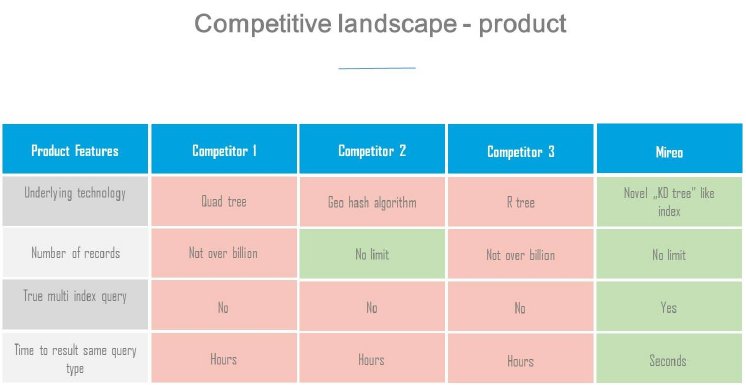
All database technologies available as of today, have been tested by MIREO; they do not scale sufficiently and have too long response times, especially when running complex queries. This is why MIREO has developed its own database technology from the ground up, with a new, efficient indexing method and sharding algorithm. Only the component for the distributed file system was taken over by a third party. Using this technology MIREO has implemented various use cases in a performant manner; it has proven to be suitable to process petabytes of geo-temporal data in the real time, whereby technically there is no obstacle foreseeable for scaling into ExaByte range.
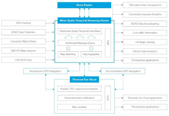
MIREO, as a company routed in GPS, Navigation and GIS markets, has so far applied this technology to relevant use cases in this areas and complements it with its access to HD maps, its proprietary AI-based routing engine and its superior map matching technology.
However, the Spatial Temporal Cluster has applications far beyond. The ability to store, manipulate and efficiently analyze big data using multidimensional polygonal queries provides for quantum leap improvements in countless applications. Especially when a certain behavior on the output side of a system needs to traced to variations on input parameters by finding correlations and sorting out their significance for an observed desired or undesired behavior, the ability to execute multidimensional polygonal queries with fast turnaround plays out strongly. Due to its efficiency it could even be automated in self-learning AI-based architectures. It is utterly impossible to envision the full scope of applications that are poised for a drastic performance improvement:
- Any sort of predictive maintenance system from automotive to industrial world
- Insurance schemes based on driving profile (so called ‘usage-based insurance’)
- Cloud connected ADAS systems in need to utilize swarm intelligence
- Fleet management systems
- City surveillance systems (including, but not limited to traffic surveillance)
- Energy distribution, monitoring and control systems, smart grids
- In general, most IoT applications, e.g. using sensory networks for process control
- Sales force monitoring systems
- Logistics monitoring systems
- Agriculture and Forestry surveillance systems
- Many Earth observation application
- Applications for analysis of customer behavior
- Medical surveillance systems and systems for diagnosis of illnesses
- …
Company Description
MIREO d.d., the Pioneer in the development of GPS Navigation and Telematics Software Solutions
Mušoga 3, Banjole, 52203 Medulin CROATIA
URL: http://www.mireo.hr/


