Contact
QR code for the current URL

Story Box-ID: 1190074

GeoCue Group Inc. 520 6th Street 35756 Madison, Alabama, United States https://www.geocue.com
Contact Bret Burghdurf
Company logo of GeoCue Group Inc.

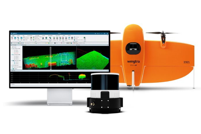
Wingtra LIDAR is now supported by LP360!

Wingtra Customers can now process, analyze, and maximize Wingtra LIDAR data, using the power of LP360 Drone to produce valuable deliverables.

(PresseBox) (Geo Week 2024, Denver, CO., )
In conjunction with Wingtra's latest product launch from Geo Week 2024, Wingtra LIDAR, GeoCue is pleased to announce the compatibility of LP360 Drone with the new sensor. As a guest sensor in LP360 Drone, Wingtra users gain the capability to effortlessly import and process their data into LP360 Drone for classification, DEM generation, transmission modeling, volumetrics, cross sections, CAD preparation, and other critical analyses.

Geospatial professionals utilizing the new Wingtra LIDAR system will now have access to an extensive toolbox of geospatial tools within LP360 Drone. The software enables users to create point clouds from UAV raw data, transform, and quality control data collected with the new Wingtra LiDAR system. This collaboration empowers users to derive products that serve various industries and applications with ease.

"This is exciting for us to collaborate with Wingtra and provide their customers with an industry-recognized and advanced desktop LiDAR software package," said GeoCue CEO, Frank Darmayan. "LP360 Drone simplifies the extraction of information and generation of deliverables in an intuitive GIS environment, enhancing the overall workflow for Wingtra LIDAR users. They will also gain valuable access to our growing collection of cloud-based tools and resources in LP360 Cloud that will make it easier for them to manage, archive, share and collaborate on geospatial projects."

Maximilian Boosfeld, CEO of Wingtra, commented, "We recognize that the LP360 software is very intuitive and works extremely well for numerous applications. This collaboration and partnership with GeoCue, will further meet our customers’ expectations and allow them to maximize their data into actionable results. This integration opens up exciting possibilities for Wingtra users, empowering them to extract valuable insights from their LiDAR data with unparalleled ease and efficiency."

This integration underscores GeoCue's and Wingtra’s commitment to delivering cutting-edge solutions that enhance the capabilities of drone-based LiDAR systems. By seamlessly integrating LP360 Drone with the new Wingtra LIDAR system, both companies aim to support geospatial professionals with enhanced data processing capabilities, ultimately driving efficiency and productivity in their workflows.

About Wingtra

Wingtra is the world's leading VTOL drone producer, headquartered in Switzerland. Since its market entry in early 2017, Wingtra has partnered with more than 80 of the biggest surveying equipment dealers across 50+ countries worldwide.

Based in the heart of Zurich, Switzerland, Wingtra houses 100+ employees, out of which more than 40 focus on R&D. The majority of Wingtra's engineers are graduates of one of the best science universities in the world, ETH Zurich. The same engineers design and assemble drones in-house and form Wingtra's support team, which is based in Europe and the Americas.

Our WingtraOne drone carries best-in-class sensors that collect survey-grade aerial data. This technologically-superior VTOL UAV is used by mapping professionals for applications that range from surveying and mining to wildlife monitoring. WingtraOne PPK offers an all-in-one solution: broad coverage, brilliant resolution, and absolute accuracy down to 1 cm (0.4 in).

To learn more about Wingtra, visit www.wingtra.com.
Website Promotion

Website Promotion

GeoCue Group Inc.

GeoCue brings geospatial experts the very best in drone surveying equipment, geospatial software, workflow, training, and support for high-accuracy LiDAR and drone mapping to help civil engineering and surveying professionals achieve successful data collection, processing, and management.

With TrueView drone LiDAR/Imaging sensors and LP360 point cloud data processing software we are the leader in LiDAR mapping processing in North America able to meet customers where they are in terms of technology adoption, budget, and resources.

To learn more about GeoCue, visit www.geocue.com.

The publisher indicated in each case (see company info by clicking on image/title or company info in the right-hand column) is solely responsible for the stories above, the event or job offer shown and for the image and audio material displayed. As a rule, the publisher is also the author of the texts and the attached image, audio and information material. The use of information published here is generally free of charge for personal information and editorial processing. Please clarify any copyright issues with the stated publisher before further use. In case of publication, please send a specimen copy to service@pressebox.de.
Important note:

Systematic data storage as well as the use of even parts of this database are only permitted with the written consent of unn | UNITED NEWS NETWORK GmbH.

unn | UNITED NEWS NETWORK GmbH 2002–2024, All rights reserved

The publisher indicated in each case (see company info by clicking on image/title or company info in the right-hand column) is solely responsible for the stories above, the event or job offer shown and for the image and audio material displayed. As a rule, the publisher is also the author of the texts and the attached image, audio and information material. The use of information published here is generally free of charge for personal information and editorial processing. Please clarify any copyright issues with the stated publisher before further use. In case of publication, please send a specimen copy to service@pressebox.de.